
 Island Modules
 Interactive Map
 Data Repository
 Gallery
 Site Map
 About
About
 Contact Us
About
The Digital Atlas of Micronesia is the foremost source of maps and geospatial information for the Federated States of Micronesia. People searching for any sort of geospatial information can come to this web-based Atlas to identify, visualize, query, analyze, and acquire datasets relevant to their interests. At the core of the Atlas are web-enabled GIS and searchable database that allow users to view and manipulate hundreds of layers of geospatial information. In addition to serving as a data repository, the Atlas is also an informational tool and incorporates hundreds of pre-made maps, charts, and datasets related to the natural and human environment of Micronesian islands. Outlined below are some of the key features of this most comprehensive geospatial data source available for the Federated States of Micronesia. Flip the cards for additional information.

ALL LOCAL CONTENT
Locally inspired and locally relevant
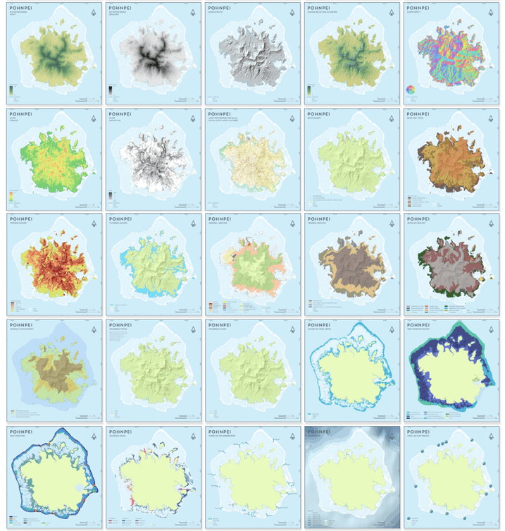
Though islands across the Pacific have many things in common, a closer look reveals that each place is distinctive, with unique and fascinating geography, environment, culture, and other aspects. Like the unmistakably Pohnpeian dance paddle shown above, this atlas is firmly connected to specific places.
Select "Gallery" in the top menu to instantly look at an island in many different ways and learn about its unique features.

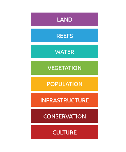
THEMATIC INFORMATION
Information, maps, and data organized by theme
Information in this atlas is organized by theme. Interested in corals? Head to the section about reefs. Want to know about local plants? Check the section on vegetation. The principal sections in the atlas correspond to key themes: land, reefs, water, vegetation, conservation, population, infrastructure, and culture.
Use the color-coded fields in the menu to move between the principal sections of the atlas and examine different themes.

DIFFERENT MODULES
Full coverage of the federated states of Micronesia
Like a tree with its branches, this Digital Atlas of Micronesia is a unified resource with distinct modules. Each module covers one of the four states comprising the Federated States of Micronesia: Yap, Chuuk, Pohnpei, and Kosrae. Except for Kosrae, each module consists of two units: one focused on the main island and the other focused on the outlying islands.
Use the blue box on the left hand side of the menu to switch between the different modules and units


ORIGINAL CARTOGRAPHY
Beutiful maps created specifically for this atals
Like a tree with its branches, this Digital Atlas of Micronesia is a unified resource with distinct modules. Each module covers one of the four states comprising the Federated States of Micronesia: Yap, Chuuk, Pohnpei, and Kosrae. Except for Kosrae, each module consists of two units: one focused on the main island and the other focused on the outlying islands.
Download high-resolution PDF, PNG, JPG, and SVG versions of any of the hundreds of maps available.


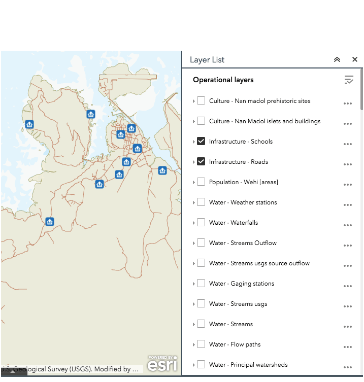
INTERACTIVE MAPS
Visit and explore the islands through easily-manipulated maps
Explore the islands—from sandy beaches down to lagoon depths and up to mountaintops—by using a series of interactive maps included in this atlas. Interactive maps allow you to zoom in and out, switch map layers on and off, examine relationships between different features, and get additional information about features of interest.
Select "Interactive map" in the top menu or "View layers" under individual maps to examine and use GIS layers on-line through your web browser.

DATA REPOSITORY
Geospatial information, imagery, and photos—all in one place
You can think of this digital atlas as a “shell” that holds information. If you seek data to download and create your own maps and analyses, this digital atlas is your “one-stop shop.” We have inventoried, enhanced, assembled together, and served here all kinds of relevant geospatial information from many sources.
Select "Data repository" in the top menu for a unified gateway to all geospatial data through a single interactive table.


EASY ACCESS
User-friendly, intuitive, and searchable
There is no part of this atlas that is difficult to reach. The easy-to-use menu at the top of every page allows you to quickly fly from one screen to another. Switching between islands, themes, maps, and data takes just one or few clicks. You can search atlas content and data or use the site map to get an overview of the entire atlas.
Select "Data repository" in the top menu for a unified gateway to all geospatial data through a single interactive table.
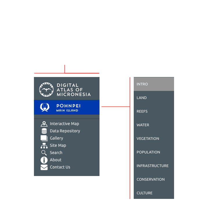
Top menu
Theme menu

RESPONSIVE DESIGN
Useful on any device in any size
This atlas uses responsive web design. It can be utilized equally well on many different platforms. You can view it on large desktop monitors as well as portable devices, including notebook computers, tablets, and mobile phones. The atlas layout and functionality adjusts to your browser, operating system, and screen size and resolution.
You can use this atlas in the office, at home, or on the go.


UPDATABLE AND FRESH
Content kep relevant and up-to-date
The user interface of this atlas is deliberately kept nearly constant so that it can remain familiar and easily accessible. However, the content within is regularly updated. Users will always get the latest versions of the data. Like fruits growing and maturing on a tree, new data is included here as soon as it is available, “ripe,” and ready to use.
The Digital Atlas of Micronesia is a continually maintained and growing resource.
